»Events Calendar»Highway Conditions»Highway Webcams»Movie Theaters»Weather Forecast»Reno Webcams»NewToReno Blog»Site Map |
Hiking Deadman's Creek Trail
Lively views from Washoe Lake State ParkSearch NewToReno

Take a Hike |
|
|---|---|
|
Check out hiking trails in the Reno area. |
Farmers Markets |
|
|---|---|

|
Shop for fresh fruit, veggies, and other goodies. |
Reno is Artown |
|
|---|---|
|
|
Enjoy Artown for the whole month of July. |
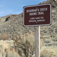
About Deadman's Creek Trail in Washoe Valley
 Deadman's Creek Trail is in Washoe Lake State Park. It starts off with spectacular views, which is a good sign for hikers. A short, uphill hike from the trailhead takes you to a gazebo overlooking the expanse of Washoe Valley, with the towering Sierra Nevada rising above the western shore of Washoe Lake. The basic hike is an out-and-back trip to the gazebo, but there are other options taking you on various loops through the Virginia Range east of the trailhead. If you climb high enough, you can peer over the crest for a view of Carson City and the mountain tops receding into the distance. This is one of my favorite Reno area hiking trails.
Hiking Details for Deadman's Creek Trail
The first part of the trail takes hikers uphill through riparian willows next to spring-fed Deadman's Creek. Water in the creek varies by season - more in spring, not much by fall. This is the only place along the Deadman's Creek Trail system with any trees. Be carefully about getting into the bushes - stinging nettle grows here. Watch for signs identifying some of the local flora and fauna.
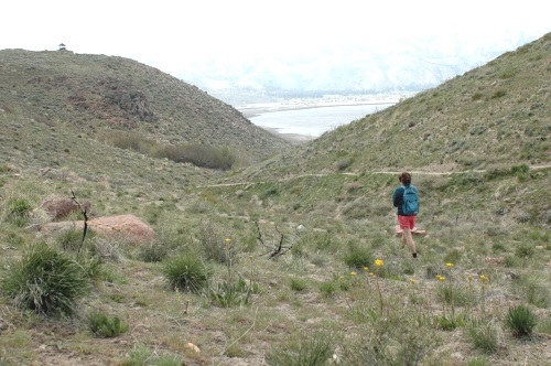
At the trail intersection after leaving the trees, the right branch leads up to a gazebo with a expansive view of Washoe Valley, Washoe Lake and Slide Mountain. In spring, the rocky slopes around the gazebo host abundant wildflowers. This is the only spot on the entire trail with shade and a place to sit that isn't a rock. It's a good place to relax and have lunch before continuing on or heading back to the trailhead.
If you go left at the intersection, the trail climbs up the side of the canyon to a dirt road. The road continues uphill and gives hikers several choices of additional routes. One takes you down to the gazebo and then back to the parking area. Others lead to the summits of nearby small peaks. The road itself is not in the park and goes all the way to Carson City. Vehicular traffic is permitted - hikers should be aware of cars, trucks, mountain bikes, equestrians, and ATVs that also frequent this part of the area.
Another trail branches off to the left before you reach the dirt road. It intersects with the main trail leading to the gazebo from the trailhead. You can descend on this alternate route from the gazebo to create a semi-loop hike rather than returning by the same path.
It's about a mile for the round-trip to the gazebo and back. Variations will add to your mileage and there are plenty of opportunities to make a Deadman's Creek Trail hike as long or brief as you like.
Hiking, mountain biking, and horseback riding are allowed on Deadman's Creek trails. You can also bring dogs, but please keep them leashed and under control so as not to disturb wildlife and other users you may encounter on the trail. Deadman's Creek Trail is natural dirt and rocks and has no ADA accessibility.
Location of the Deadman's Creek Trailhead
Deadman's Creek Trail is at the southeast edge of Washoe Lake State Park. It's around 25 miles south of Reno, depending on where you start. To reach the trailhead from Reno, drive south on I580 / U.S. 395. Stay on the freeway to the south end of Washoe Valley and take the Eastlake Boulevard exit. Look for a sign for Washoe Lake State Park. Turn left and follow Eastlake Boulevard a couple of miles to the parking area on your right. There is a trailhead sign and you can see the gazebo on the hill. There is only room for a few cars, but you can park in some wide spots along the shoulder if need be. This parking space is not in the park's fee areas and is free. There is more parking across the road, which is in a day-use area for Washoe Lake State Park and requires payment of a fee.
Little Washoe Lake Trail
Little Washoe Lake is at the north end of Washoe Valley. There are a couple of trail variations, taking hikers either along the shoreline or above it and closer to the road. To reach Little Washoe Lake from Reno, take old U.S. 395 (not the I580 freeway) south. At the top of the hill between Pleasant Valley and Washoe Valley, turn left on Eastlake Boulevard. Trailhead parking is on the right. This area is within Washoe Lake State Park and a day-use fee is required.
Nearby Parks and Hiking Trails
These nearby Washoe County parks also have a variety of hiking trails...
- Davis Creek Regional Park
- Bowers Mansion Regional Park
- Slide Mountain Trail
- Tahoe Meadows Trails
- Mt. Rose Trail
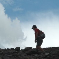
Hiker enjoying Deadman's Creek Trail in Washoe Lake State Park, south of Reno, Nevada. Photo © Stan White
Sponsored Links
Sponsored Link
| Share NewToReno(dot)com | |||||
|---|---|---|---|---|---|
»Home »Contact Us »About Us »Privacy Policy »Disclaimer »Site Map
Copyright © NewToReno(dot)comTM